Related Articles


Models of Exploration by Remote Sensing
Surface lineations or lineaments, visible in satellite imagery and on aerial photographs, are being used to generate prospects based on the assumption that the lineaments are associated with rejuvenated basement features. In the Great Plains province of the United States, exploration geologists suspect that recent substantial basement uplifts have strongly revived ancient fracture systems. Such basement fault rejuvenations are visible in modern surface topography and drainage patterns (Figure 1).

The episodes of uplift have affected buried fracture zones in petroleum reservoirs and in the feeder systems leading to them. Surface lineaments, therefore, have been used to find shallow gas prospects in the fractured Niobrara Chalk. Ancient fault-block movements may also have influenced patterns of sedimentation.
In the late 1970s, the Williston basin saw major exploration for microfractured reservoirs in the Ordovician Red River carbonates and in the Mississippian (Lower Carboniferous) limestones of the MonDak trend along the Montana-North Dakota state line. While most prospects in this deep expensive play are based on detailed proprietary seismic data, attempts have been made to apply surface lineaments to the search for subsurface fracture zones. Episodic basement faulting has long been recognized as important in creating prospects in the Williston basin. For example, Figure 2,


and Figure 4 show a small residual anticline, prospective for Mississippian production, caused by slumping that followed Late Mississippian solution of Prairie Evaporite along a basement fault.

Theoretically, such a prospect could be generated by any of these methods:
- searching with seismographic for structural highs surrounded by collapsed zones;
- searching with gravity meter for abrupt edges of evaporite beds (strong minimum gradients)
- searching for the fault zones which localized the solution of evaporite beds by recognizing their rejuvenated surface traces.
All geologists do not agree on how to interpret surface lineaments. One school considers mainly the vertical motions of basement blocks. Microfracturing in structurally flexed strata, which is caused by basement uplift or subsidence, is a realistic and commercially important process. It is likely that the use of surface lineaments to generate prospects for fractured reservoirs will become more important during the next few years. (Obviously such evidence must be used in connection with conventional structural maps.)
But the lateral – as well as the vertical – motions of basement fault blocks may create significant petroleum prospects. Probably each episode of a basement fault’s activity involves simultaneous vertical and horizontal motions. The trick is to identify (a) which faults were active, (b) at which epochs, and (c) in which senses. From such analysis the positions and trends of axes of potentially productive anticlines or microfractured folds may be predicted.
This specialty could become much more important than it is if we develop a consensus about how basement faults move and how associated wrinkles occur. Tectonic patterns are fundamentally non random, and that being so, geologists inevitably will succeed in rationally analyzing them. Then the patterns of faulting could possibly be used to generate local anticlinal and fracture prospects.
Another type of prospect-generating anomaly seen from LANDSAT imagery is the “hazy” anomaly. It is thought that “hazy” anomalies display the effects of geochemical changes in surface layers resulting from upward migration of hydrocarbons from underlying buried accumulations. From the total 57 “hazy” anomalies in the Anadarko basin (Figure 5), 42 coincide with producing fields and six are known to be nonproductive structures.
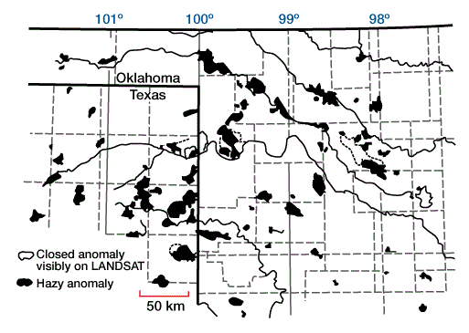
At this stage a “hazy” anomaly in unexplored territory should probably be regarded as a lead for further exploration.