ad
Geology

Prospect Model in Petroleum Geology

Deltaic-Growth Fault Model ( Devillier Gas Field )

The Devillier field, an overpressured gas field in the Texas Gulf Coast, is a case in which geologists were looking for a subtle stratigraphic trap within a region saturated with anticline and growth fault production. The prospect was located within the highly productive Loxostoma trend, along the downthrown side of a major line of growth faults, the Vicksburg flexure (Figure 1).

The Devillier field, Geological prospecting, Petroleum exploration, Reservoir modeling, Seismic interpretation, Well log analysis, Stratigraphy, Structural geology, Petroleum systems, Source rock analysis, Hydrocarbon potential, Reservoir characterization, Prospect evaluation, Trap types, Migration pathways, Seismic surveys, Petroleum geophysics, Play fairway analysis, Basin analysis, Rock properties, Porosity and permeability, Reservoir engineering, Well testing, Production forecasting, Reserves estimation, Risk assessment, Prospect model
FIGURE 1

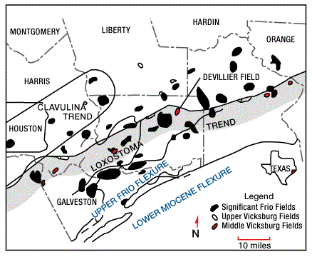
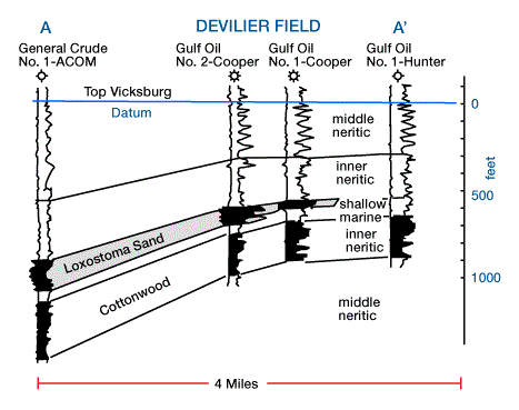
In this trend, petroleum is produced from the Upper Vicksburg (Lower Oligocene) Loxostoma “B” sandstone, which lies within a sequence of alternating sandstones and shales. The Devillier field is an example of a trap that is largely controlled stratigraphically. Its existence is the result of a pinchout of deltaic sand facies against prodelta shale facies (Figure 2), but shale diapirism and growth-fault tectonics also played a role in sedimentation and trapping.

Geological prospecting, Petroleum exploration, Reservoir modeling, Seismic interpretation, Well log analysis, Stratigraphy, Structural geology, Petroleum systems, Source rock analysis, Hydrocarbon potential, Reservoir characterization, Prospect evaluation, Trap types, Migration pathways, Seismic surveys, Petroleum geophysics, Play fairway analysis, Basin analysis, Rock properties, Porosity and permeability, Reservoir engineering, Well testing, Production forecasting, Reserves estimation, Risk assessment, Prospect model
FIGURE 2

The reasoning that established Devillier as a viable prospect was largely threefold. First, a well to the southwest contained 90 ft of sand at the target Loxostoma horizon (Figure 3). It was believed to be deltaic in origin, like many other older and younger units in this part of the Gulf Coast. However, this sand was absent in another well three miles farther to the east.

The target loxostoma horizon devilier field, Geological prospecting, Petroleum exploration, Reservoir modeling, Seismic interpretation, Well log analysis, Stratigraphy, Structural geology, Petroleum systems, Source rock analysis, Hydrocarbon potential, Reservoir characterization, Prospect evaluation, Trap types, Migration pathways, Seismic surveys, Petroleum geophysics, Play fairway analysis, Basin analysis, Rock properties, Porosity and permeability, Reservoir engineering, Well testing, Production forecasting, Reserves estimation, Risk assessment, Prospect model
FIGURE 3

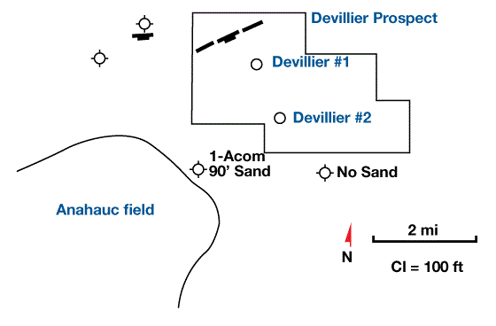
Thus, it was reasoned that the Loxostoma sand was deposited as thick distributary mouth bars that pinched out laterally against interdistributary and pro-delta shales. Second, fault cuts in two shallow wells suggested that the Vicksburg flexure lay just to the north of the prospect, and would likely parallel the Oligocene paleoshoreline (Figure 3). The target sands should thicken abruptly on the downthrown side of the growth fault. Finally, available seismic lines indicated deep structures. Three potential closures could be seen on seismic lines at the target horizon (Figure 4).

Seismic line Devillier field, Geological prospecting, Petroleum exploration, Reservoir modeling, Seismic interpretation, Well log analysis, Stratigraphy, Structural geology, Petroleum systems, Source rock analysis, Hydrocarbon potential, Reservoir characterization, Prospect evaluation, Trap types, Migration pathways, Seismic surveys, Petroleum geophysics, Play fairway analysis, Basin analysis, Rock properties, Porosity and permeability, Reservoir engineering, Well testing, Production forecasting, Reserves estimation, Risk assessment, Prospect model
FIGURE 4

The geologists looked first at the central, most promising feature (Figure 5).

Contour map devillier field, Geological prospecting, Petroleum exploration, Reservoir modeling, Seismic interpretation, Well log analysis, Stratigraphy, Structural geology, Petroleum systems, Source rock analysis, Hydrocarbon potential, Reservoir characterization, Prospect evaluation, Trap types, Migration pathways, Seismic surveys, Petroleum geophysics, Play fairway analysis, Basin analysis, Rock properties, Porosity and permeability, Reservoir engineering, Well testing, Production forecasting, Reserves estimation, Risk assessment, Prospect model
FIGURE 5

They reasoned that the crest of the structure could lack sand, so the first wildcat (well #1) was located on its flank. This test encountered 100 ft of the target sand, but it was water-wet. A second well (well #2) was then located about one mile away, closer to the crest, and became the discovery well of the Devillier field (Figure 5). The other two anomalies were also tested. The structure on the east lacked sand, as the depositional model had predicted (Figure 6).

The structure devillier field, Geological prospecting, Petroleum exploration, Reservoir modeling, Seismic interpretation, Well log analysis, Stratigraphy, Structural geology, Petroleum systems, Source rock analysis, Hydrocarbon potential, Reservoir characterization, Prospect evaluation, Trap types, Migration pathways, Seismic surveys, Petroleum geophysics, Play fairway analysis, Basin analysis, Rock properties, Porosity and permeability, Reservoir engineering, Well testing, Production forecasting, Reserves estimation, Risk assessment, Prospect model
FIGURE 6

The western structure did contain thick Loxostoma sands, but proved to be dry. Hindsight reasoning suggests that the overpressured shales must have caused all of the gas that migrated through the Loxostoma sand to be flushed into the stratigraphic pinch-out at Devillier.

Devillier field is a specific type of subtle trap, formed by a unique set of geologic circumstances that involve the interplay of growth fault tectonics, shale diapirism and overpressuring, and deltaic sedimentation. Other subtle traps, perhaps totally different and with their own unique features, still remain to be discovered in this and other geological provinces.

Previous page 1 2 3 4 5 6 7 8 9 10Next page

Related Articles

Leave a Reply

Your email address will not be published. Required fields are marked *

ad
Back to top button