Related Articles


Survey Tools
Depending on the type of tool, measuring instruments record the following parameters:
- Drift: the inclination of the wellbore from vertical.
- Azimuth: the direction of the wellbore in the horizontal plane (i.e., the “compass direction,” usually with respect to magnetic or true North).
- Toolface orientation: the azimuthal direction of a bent housing or other deflection tool.
Mechanical Drift Indicator
The oldest and simplest type of directional survey tool is the mechanical drift indicator (Figure 1).
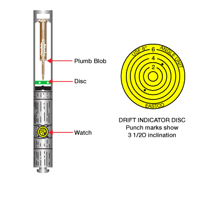
This device works on a pendulum, or “plumb-bob” principle. It gives no indication of azimuth, but measures only a well’s inclination from vertical. It is used today for surface hole intervals, shallow vertical wells and other applications where dog-leg severity and horizontal departure are not likely to become significant problems. The use of this device typically involves two inclination measurements: an initial measurement, followed by one for verification purposes.
Magnetic Survey Tools
Magnetic survey tools record the inclination and azimuth at various points, or stations, along the well course. Two basic types of tools are available:
- Magnetic Single-Shot: Records one measurement, usually near the bottom of the well. It is comprised of a precision floating compass, a device to superimpose concentric circles (calibrated in degrees) with a plumb-bob type indicator, and a camera that photographs the plumb-bob and compass face to record both drift and direction. It cannot record compass directions inside regular drill collars or casing because steel pipe blanks off the Earth’s magnetic lines of force. Thus, it is used only in open hole or inside non-magnetic drill collars.
- Magnetic Multi-Shot: Records multiple measurements of borehole drift and azimuth on a single run into the hole. It consists of a modified magnetic single-shot instrument with the single frame camera replaced by a multi-frame camera. It also has incorporated timing devices, including a motion sensor, and is used for multi-depth drift and direction measurements. Like the single-shot, It must be in an open hole or inside non-magnetic drill collars to measure compass directions.
Magnetic survey tools can be dropped or pumped to bottom, lowered on slick line or wireline, or run as part of a measurement-while drilling (MWD) package. When tools are dropped to bottom–typically before tripping pipe–they can be recovered when the pipe is pulled, or else by means of an overshot.
The basic components of a conventional magnetic survey tool are as shown in Figure 2:
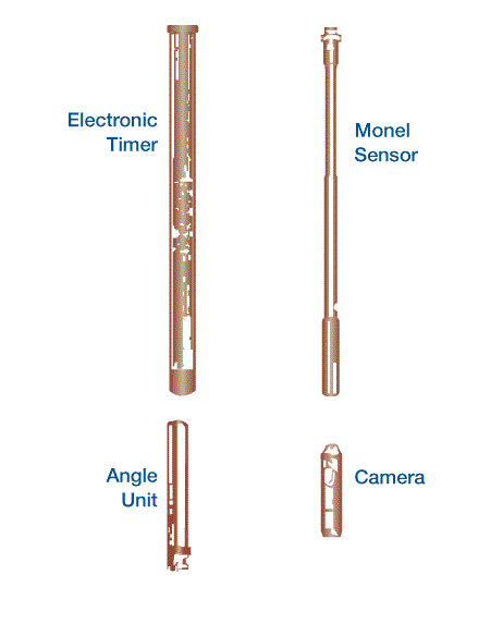
- a magnetic compass and angle-indicating unit
- a camera unit for recording measurements on a photographic
- a timer or motion sensor, which activates the device at a desired time or depth interval
In place of camera-based devices, more modern magnetic survey tools offer solid-state electronic recording capabilities. These devices are armed by means of a surface computer, and then run like standard multi-shot tools. Survey data are recorded electronically using highly sensitive magnetometers and accelerometers, stored, and then retrieved and processed by the computer. Their main advantages are time savings, improved accuracy, continuous readings with surface readouts, and elimination of errors caused by manually reading film records (Baker-Hughes Inteq, 1993).
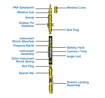
To prevent magnetic interference from the drill string,magnetic instruments must be run inside non-magnetic drill collars. They may be run with a collar, or “monel” sensor (Figure 2 When run in conjunction with a non-magnetic orienting sub or collar, they can be used to determine tool-face orientation Figure 3 illustrates a typical running assembly for a single-shot magnetic tool. Note the orientation sub at the bottom of the assembly, which is used to orient deflection tools for directional drilling.

Figure 4 shows a typical assembly for a multi-shot magnetic tool.
Magnetic tools measure azimuth based on the earth’s magnetic field. Consequently, they measure magnetic, rather than true north, and we have to correct for this difference, or declination, when we report these measurements (Figure 5, The earth’s magnetic field and Figure 6, Declination, magnetic to true north).


Gyroscopic Survey Tools
Gyroscopic survey tools, like magnetic devices, are used to measure inclination, azimuth and tool orientation. The primary difference is the use of a gyroscopic compass, which maintains a fixed reference direction and measures relative changes in direction at selected depths with the aid of a timer and a motion sensor. Thus, unlike a magnetic survey tool, it can measure azimuth without using the Earth’s natural lines of magnetic force. This makes it suitable for surveying wells where casing has been set or where there is magnetic interference from nearby wellbores. Gyroscopic tools also contain drift-recording instruments for measuring wellbore inclination.
Like magnetic instruments, gyroscopic tools can have single or multi-shot capabilities, and many devices have electronic, computer-aided data recording and processing capabilities, along with continuous survey, surface readout features. They are not as rugged as magnetic tools, however, and so must be run on wireline.
Although gyroscopes are not subject to magnetic interference, they are sensitive to drift caused by the earth’s rotation and are affected by the position of the wellbore on the earth’s surface. With conventional instruments, it is therefore necessary to optically orient the gyroscope on surface, and then to make several check shots when running in the hole. Bourgoyne et al (1991) describe this orientation procedure.
“North-seeking” gyroscopic tools employ rate-gyroscopes and accelerometers to measure the earth’s rotation rate and gravitational force at each survey station. This eliminates the need for optical surface alignments and pre-survey drift checks, improving both survey time and accuracy. Such tools are particularly useful for surveying through pipe in deep wells, and in situations that require a high degree of survey accuracy.
Gyroscopic survey systems have one overriding limitation in horizontal and high-angle directional drilling, in that they cannot be run at inclination angles of greater than 70°.
The inertial guidance systems long employed in aircraft navigation are also applicable to directional well surveying. An inertial navigation system is a position measurement tool, which determines a moving body’s position in three dimensions by mathematically integrating the measured components of its acceleration. Unlike conventional directional surveys, which calculate position based on measurements of inclination and azimuth angles, inertial systems provide a direct means of measurement.
Inertial navigation systems are fast, extremely accurate, and relatively independent of hole inclination and position on the earth. They are particularly useful in high latitude, high-angle wells such as those drilled in the North Sea (Baker-Hughes Inteq, 1993).
Steering Tools
Steering tools are used to measure drift, direction and tool face during semi-continuous drilling. An instrument package containing any of the tools mentioned above is sent downhole, and a coder converts data measurements to electrical pulses and transmits these to the surface through a shielded electric conduit to digital or TV-type displays / recorders. Thus measurements are available immediately at the surface for use in controlling hole direction.
Measurement-While-Drilling (MWD)
MWD systems record measurements at or near the bit as drilling proceeds, and the data are transmitted immediately to the surface by pressure pulses in the mud column or by other methods that do not require an electrical conduit. This eliminates many problems common to other measurement systems. Along with directional data, these systems can also carry third-party tools to measure key drilling parameters (e.g., rate of penetration, rotating speed, mechanical efficiency log, sticking pipe indicator, strain gauge, temperature, pressure, etc.) and formation evaluation data (e.g., gamma ray, resistivity, conductivity, neutron, etc).