Related Articles


Geosteering Overview
Over the years, oil companies have had to take up the challenge of developing difficult, sometimes marginal prospects. As “easy” reservoirs become depleted, the challenge is to produce oil that was left behind, or to develop smaller, thinner, fractured, or low-quality reservoirs that had previously been passed over as poor prospects. Extended reach, horizontal, directional drilling, and multilateral wellbores have helped oil companies to book more reserves, and optimize production of these “poor” prospects.
To develop bypassed reserves or hard-to-reach reservoirs requires precise targeting of the wellbore through a process known as GeoSteering. This approach to drilling advances the integration of Geology, Geophysics, and Petroleum Engineering toward a common goal of improving production. This module reviews valuable insights into the GeoSteering process, provided by Kenneth Bowdon, President of Horizontal Solutions, International, a company with experience gained over the course of steering nearly 2000 horizontal wells.
GeoSteering Defined
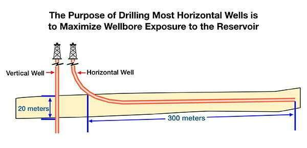
GeoSteering is the application of geologic and engineering skill to direct a horizontal or extended-reach wellbore path, based upon knowledge of the enclosing stratigraphy, with the expressed aim of maximizing wellbore exposure to the target reservoir.
(Figure 1: Maximizing wellbore exposure).
GeoSteering is not the same as directional drilling, and it is not simply a directional tool, or a gamma ray or a resistivity device mounted above the bit. GeoSteering is not a service offered by a consulting company or a service company. GeoSteering is not the wellbore plan. All of these components are important parts of the GeoSteering toolbox.
Directional Drilling
Briefly stated, directional drilling is the process of manipulating specialized downhole tools to mechanically guide a deviated, high-angle or extended-reach wellbore.
GeoNavigation
GeoNavigation involves the analysis of critical pieces of information needed to make a steering decision. The GeoSteering Team uses the geonavigation services of consultants and service companies who either provide hardware, software, or interpretations of the well data obtained as it is being drilled. This data ranges from drilling performance data to directional surveys, MWD/LWD data and geophysical data. The service companies and consultants may play a major role in successfully steering a horizontal well under the direction of the GeoSteering Team. They can, however, also produce disastrous results if they are allowed to actually make steering decisions based only upon their specific area of expertise.
Having the right geonavigation hardware and software is critical to the success of the well. But the methods used to interpret the data, as well as the individuals who make the interpretation will play an even greater role in the success of the geosteering project.
The Geosteering Team
A GeoSteering Team is often called upon to prioritize and evaluate a wide range of geonavigation data, and then communicate steering instructions to the Directional Driller.
The GeoSteering Team may grow or shrink on the basis of project complexity, but typically consists of a Team Leader and Directional Driller (at a minimum). In some cases, the team will include a Wellsite Geologist, Drilling Engineer or Company Drilling Representative, and may sometimes include a Geophysicist or Petrophysicist. The Team’s composition should be based upon the minimum number of people needed to interpret the range of geonavigation data generated as the well is drilled. The Team evaluates only information that is essential to the steering decision. (Petrophysical information is typically evaluated only after steering decisions are made, except in cases where water saturation is used to indicate proximity to the water leg of a reservoir.)
Companies utilize a variety of methods to arrive at key geosteering decisions.
- Some companies prefer to have an engineer and a geologist who is a geosteering specialist on location, to make “instant decisions.”
- Other companies have an elaborate system to transfer data real-time to the office, for a team of geologists, geophysicists, and engineers to pore over.
- Some companies use consultants to evaluate data from a horizontal well, and then assign a single individual or team to coordinate, compare and act upon these interpretations.
The structure of any geosteering team will depend upon the corporate culture, the level of horizontal well expertise possessed by the geoscience team, and the company’s commitment to keep its well in zone. Regardless of the team’s composition, the members all need to adapt an interdisciplinary mindset, as they will need to make sense of a wide range of data -some of which will invariably come from outside of their field of expertise. (Figure 2: The role of the Geologist)

Characteristics of a Successful Geosteering Team
The composition of the geosteering team will vary, depending upon the expertise of available personnel. Regardless of the makeup of the Geosteering Team, there are certain characteristics common to most successful teams.
- The Geosteering Team should be comprised of geoscientists that have the authority to make steering decisions.
- Once the Team is formed, Management should stay out of the steering decision process. Steering decisions may be required at any time, and are always time-sensitive. If a decision must wait for approval up the chain of command, then the recommendation might quickly become obsolete as the well continues to drill, thus requiring a more radical correction that could even jeopardize the hole.
- The Geosteering Team should be as small as possible while still covering the skill sets required by the geosteering project. When too many people are involved in a decision and no one in particular is in charge, then only mis-direction will occur. A compromise steering decision is not a decision -it is a mistake. At the very minimum, a team should include at least one cross-trained geoscientist and the Directional Driller. Additions to the Team should consist only of those individuals needed to determine the geometric, stratigraphic, and structural position of the bit.
- The focus must always remain upon targeting the reservoir, not evaluating the reservoir. Individuals on the Team must be trained in complimentary disciplines so that each understands the input from others on the team, and each understands what it is possible for the Directional Driller to do.
- Each Team member should have a defined role and be fully informed about the objectives of the well. The frustration of not “being in the loop” may cause friction and confusion, which may in turn cause errors in judgment and uncooperative team members.
- There must be a Team Leader.
- An integral part of the Team concept is the identification of a Team Leader, who has final authority to “pull the trigger.” The Team Leader should have experience and should be cross-trained to understand horizontal drilling from a Geologic, Drilling, Completion, and Reservoir perspective, and must be able to collate information from diverse sources to derive the whole picture of what is happening down the wellbore.
Geosteering is an art that is practiced through acquired skill. As in all such endeavors, there will be some people who just have a natural ability for steering a well because they can visualize in three dimensions, and can work on the basis of incomplete data from multiple sources. Others may have a harder time grasping the concepts, but all can improve their skills through cross-disciplinary training combined with experience.
To steer an actively drilling well, it is important to determine what kind of information the geosteering team needs to make good steering decisions. Then the team should determine how the data will be interpreted, and how the interpretation will be used to communicate steering decisions to the Directional Driller.
In the following sections, we will provide an overview of the reasons for drilling directional wells, and then discuss tools, methods, and terminology used in drilling deviated wells.
