Depositional Processes and Lithologic Characteristics
The overall discharge of a braided stream is low compared to the supply of sediment. It is also sporadic – punctuated by extreme fluctuations that range from no water at all to torrential flooding. Slopes are relatively high (usually 3° to 10°) and most sediment is coarse-to medium-grained sand, with sometimes major amounts of gravel and more minor contributions of silt and clay. The preservation of this environment requires that the braiding river flow through a region of subsidence, for example a developing basin, in relative proximity to a rising orogenic front. This condition exists in a number of specific tectonic settings, such as intermontane, subsiding coastal and rift graben basins. Like alluvial fan deposits – with which they are often genetically connected – braided stream complexes are especially common in sediments of Late Paleozoic and Middle Mesozoic-Early Tertiary age, when tectonic activity was extensive over large regions of arid or semiarid climate.
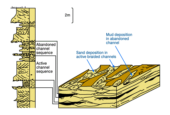
Modern braided stream deposits are well studied. The shape of individual bars can be either tabular and linear, or curving. However, complete morphology is rarely preserved in the sedimentary record; most bar and channel sequences show a great deal of internal truncation. (Figure 1, Surface features and facies model of a braided channel system.

Sedimentation takes place almost entirely within the shifting complex of channels with some small silt deposition in abandoned channels. No flood plain exists; migration of the channel complex, due to tectonic tilting, for example, leads to the creation of extensive sand bodies.)
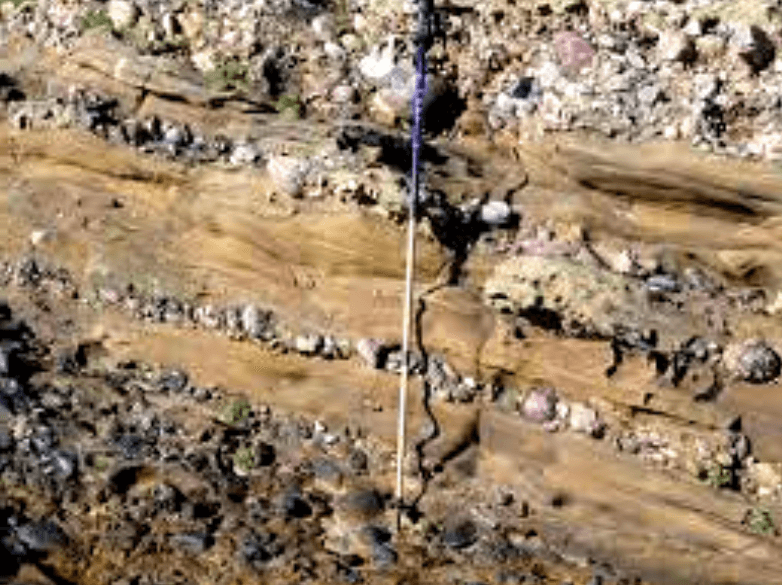
Floodwaters will quickly overflow the shallow channels and cover the entire alluvial plain. During this time, new channels will be scoured and cut, and old ones filled. Bar migration occurs as discharge increases and then decreases: upstream portions lose sediment to rising currents, while the downstream end and flanks build as the water level and carrying capacity of the stream diminish. A vertical section through a braided alluvial complex, then, will show a high degree of cut and fill. (Figure 2, Photo showing cut and fill channeling and general character of a recent braided stream deposit.)

Some deposition of finer-grained material can also occur, particularly in channels abandoned for longer periods of time. In more humid regions, vegetation may colonize some bars and stabilize them with soil cover. Silt and clay that settle in abandoned channels are commonly ripped up during flooding and may be preserved as intraformational conglomerate.
Vertical sequences are commonly comprised of multiple, stacked channels, each showing an overall progression that begins with the sharp erosional base of a channel floor (Figure 1). Above this, in ascending order, are gravelly, conglomeratic debris with imbricated, subrounded pebbles; coarse, crudely bedded sands with some gravel; and medium-grained sandstone that fines upward. The more coarse, pebbly sands often compose as much as 90% of the total lithology. Those sandstones without gravel show lamination, planar-bedding, cross-stratification of both trough and tabular types, and where they are more fine-grained, small-scale ripple development. Due to rapid changes in water level (which causes sudden changes in intergranular pore pressures) soft sediment (also called “quicksand”) deformation is also common in braided alluvial deposits and results in convoluted bedding from both water-escape and recumbent or collapsed cross-bedding. Sorting ranges from poor, near the base of such a sequence, to very good at the top. However, the continual cutting and filling of channels ensures that very few complete sequences exist and, therefore, that sudden lateral and vertical variations in sorting and grain size are characteristic.
The lack of fine r-g rained material theoretically means that porosities and permeabilities should be high; however, the above-mentioned changes in sorting and size, as well as diagenetic influences, often reduce these parameters considerably. Figure 3 (Plots of porosity versus permeability showing rapid vertical change, Elk City field, Oklahoma),

gives two examples of porosity-permeability profiles through a rather narrow producing interval that shows substantial and unpredictable variation. Such profiles are extremely useful in indicating local, high-porosity/permeability zones.
 Petro Shine The Place for Oil and Gas Professionals.


