Related Articles


Characteristics and Limitations
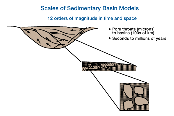
All basin models simulate responses to geologic processes, are based on a combination of theoretical or empirical generalizations and commonly incorporate physical, chemical and conservation laws. Geological processes operate over a wide range of temporal and spatial scales (Figure 1). Temporal scales range from a few seconds (saltation of a sand grain) to hundreds of millions of years (thermal history), and spatial scales range from microns (pore throats) to hundreds of kilometers (tectonic regions).
Many types of basin models have been developed during the last two decades. Most originated from separate disciplines within the earth sciences. Consequently, most basin models are narrow in scope, and only recently have there been attempts to integrate models that cross disciplinary boundaries. In the industry, the term basin model implies a geodynamic or geophysical model of large-scale basin subsidence that incorporates some aspect of thermal and maturation history.
An ideal basin-fill model would simulate everything from the deposition of sand grains to the buckling of the lithosphere. We cannot build such an ideal model because of our ignorance of geologic processes, their complexities, and computational limitations. However, most problems require only that a model address particular questions and produce results at an appropriate level of detail. Thus, we can limit a particular model to specific scales and constrain it within specific initial and boundary conditions.
If we could completely limit our models to specific temporal and spatial scales, our problem would be less demanding. But our models are complicated by the dynamic interdependency and feedback between processes of different scales. Our task is to model the dynamic responses to both large- and small-scale processes using “intelligent” approximations. Such approximations are difficult because we must provide quantitative answers to questions about the geologic record, even though our ignorance and uncertainty may be considerable.
The stratigraphic record is the result of processes acting before, during and after deposition of sediments, and upon specific basin configurations that are the results of unique histories. For example, sediment supply depends on previous tectonic, climatic and sedimentary processes operating in the regional basin setting; the physical orientation and types of grains within a particular deposit depend on the fluid flow dynamics at the time of deposition; and the final thickness of a deposit depends on the volume of the initial storage space plus compactional and diagenetic processes operating after deposition. The sedimentary record is the result of complex processes, and it is difficult to unravel these processes because we observe only the final result.
We know from intuition and study that the complexity of geologic processes makes developing a basin model difficult because many geologic phenomena are not well-understood. We often do not know which processes are important, nor their relative values, uncertainties, or interdependencies. We may not know whether a specific geologic process/response system is linear or non-linear. Our knowledge of feedback mechanisms between processes and responses is woefully inadequate. Consequently, traditional paradigms for building deterministic models are not always appropriate; we need to develop other techniques for building models. Our task is analogous to the difficulty of understanding the seismic response before the development of geophysical field theory. We may not develop a “field theory” for geologic systems, but we need a model-building tool with similar power for developing understanding and analysis.
Aside from the imperfect understanding of processes and responses in natural systems, other flaws or errors are inherent in basin models. First, we must represent natural systems through a set of statements and mathematical expressions that are simplifications and approximations of the real world. Second, we must consider the appropriateness of the model dimension(s) selected to simulate the real world. A two-dimensional model may be a poor approximation of a four-dimensional world (Figure 2, Comparison of deltaic deposition using A two spatial dimensions and B three spatial dimensions.
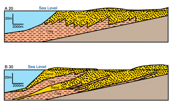
Model input data was equivalent; differences result from approximation of dimensions. Third, we must consider the range of values for the variables within the models. In too many instances the possible ranges in values, and the uncertainties of these ranges, are unknown.
These inherent flaws demonstrate the need for testing, calibrating and validating models at all stages of their development. We must also determine the accuracy and uncertainty of the measured values, if comparisons between models are to be useful. In some instances, models make predictions or provide results that are identical in type and form to some property that we can measure directly; for example, sediment thickness or lithology. In many instances, however, models provide results that we can not directly compare to an observed data type; for example, heat flow or water depth. In these cases, we must compare the predicted value to the measured value of a property we consider an appropriate proxy for the modeled property; for example, vitrinite reflectance as a proxy for the time/temperature index (TTI), or paleontologic or facies information as a proxy for water depth.