ad
Geology

Prospect Model in Petroleum Geology

Reef Models

Prospect generation is relatively straightforward in many reef trends because the reef itself normally provides both reservoir and trap, and the enclosing rock is commonly both seal and hydrocarbon source. Some major unexplored North American reef trends still exist. For example, the Jurassic reefs on the Atlantic continental margin are the best, and perhaps last hope of major reserves In this area. Without boreholes, however, geologists can at most only predict the existence of potential subsurface reef trends. There, the task of generating the individual reef prospects falls to seismologists. Some criteria for detecting reefs with the seismograph are:

  • compaction structures in bedding above reef
  • steep dips along reef edges
  • diffractions from reef edges
  • evidence of velocity anomalies
  • zone of weak reflections
  • interruptions in lateral continuity of strata
  • disappearance of reef platform reflections (Lyons et al. 1972)

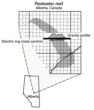
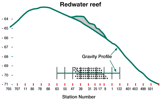
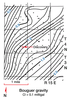
In detecting reefs with the gravimeter, the usual criterion is the observance of local gravity maxima, which are expressions of higher density carbonate reefs enclosed in lower density shale or salt. Compaction anticlines that have developed over reefs may contribute to the maximum gravity anomaly. A major Devonian field, the Red-water reef oil field in Alberta, Canada, is clearly detected by gravimetry (Figure 1 and Figure 2)

Devonian field Red water reef oil field Alberta Canada, Geological prospecting, Petroleum exploration, Reservoir modeling, Seismic interpretation, Well log analysis, Stratigraphy, Structural geology, Petroleum systems, Source rock analysis, Hydrocarbon potential, Reservoir characterization, Prospect evaluation, Trap types, Migration pathways, Seismic surveys, Petroleum geophysics, Play fairway analysis, Basin analysis, Rock properties, Porosity and permeability, Reservoir engineering, Well testing, Production forecasting, Reserves estimation, Risk assessment, Prospect model
FIGURE 1

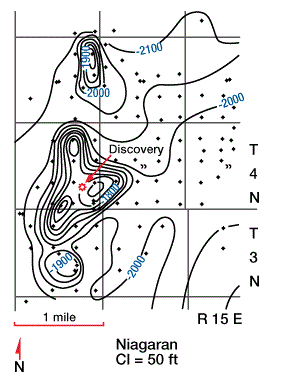
Niagaran (Silurian) pinnacle reefs in Michigan also have been found by gravimetry.

Niagaran Silurian pinnacle reefs in Michigan found by gravimetry, Geological prospecting, Petroleum exploration, Reservoir modeling, Seismic interpretation, Well log analysis, Stratigraphy, Structural geology, Petroleum systems, Source rock analysis, Hydrocarbon potential, Reservoir characterization, Prospect evaluation, Trap types, Migration pathways, Seismic surveys, Petroleum geophysics, Play fairway analysis, Basin analysis, Rock properties, Porosity and permeability, Reservoir engineering, Well testing, Production forecasting, Reserves estimation, Risk assessment, Prospect model
FIGURE 2
Niagaran Silurian Bouguer Gravity, Geological prospecting, Petroleum exploration, Reservoir modeling, Seismic interpretation, Well log analysis, Stratigraphy, Structural geology, Petroleum systems, Source rock analysis, Hydrocarbon potential, Reservoir characterization, Prospect evaluation, Trap types, Migration pathways, Seismic surveys, Petroleum geophysics, Play fairway analysis, Basin analysis, Rock properties, Porosity and permeability, Reservoir engineering, Well testing, Production forecasting, Reserves estimation, Risk assessment, Prospect model
FIGURE 3
Niagaran Silurian Residual Gravity, Geological prospecting, Petroleum exploration, Reservoir modeling, Seismic interpretation, Well log analysis, Stratigraphy, Structural geology, Petroleum systems, Source rock analysis, Hydrocarbon potential, Reservoir characterization, Prospect evaluation, Trap types, Migration pathways, Seismic surveys, Petroleum geophysics, Play fairway analysis, Basin analysis, Rock properties, Porosity and permeability, Reservoir engineering, Well testing, Production forecasting, Reserves estimation, Risk assessment, Prospect model
FIGURE 4

show the Bouguer anomaly map and the residual maximum feature which led to the discovery of the Boyd field a Silurian Niagaran reef in the Michigan basin (Figure 5).

Niagaran Michigan basin, Geological prospecting, Petroleum exploration, Reservoir modeling, Seismic interpretation, Well log analysis, Stratigraphy, Structural geology, Petroleum systems, Source rock analysis, Hydrocarbon potential, Reservoir characterization, Prospect evaluation, Trap types, Migration pathways, Seismic surveys, Petroleum geophysics, Play fairway analysis, Basin analysis, Rock properties, Porosity and permeability, Reservoir engineering, Well testing, Production forecasting, Reserves estimation, Risk assessment, Prospect model
FIGURE 5

The discovery of Black Lake field, Nachitoches Parish, Louisiana was the result of persistent prospect generating by a geologist. In an area covering about four townships, six dry holes had penetrated the Sligo Limestone (Lower Cretaceous) (Figure 6 and Figure 7) The three downdip holes contained “Pettet” reef facies,

Sligo Limestone Lower Cretaceous, Geological prospecting, Petroleum exploration, Reservoir modeling, Seismic interpretation, Well log analysis, Stratigraphy, Structural geology, Petroleum systems, Source rock analysis, Hydrocarbon potential, Reservoir characterization, Prospect evaluation, Trap types, Migration pathways, Seismic surveys, Petroleum geophysics, Play fairway analysis, Basin analysis, Rock properties, Porosity and permeability, Reservoir engineering, Well testing, Production forecasting, Reserves estimation, Risk assessment, Prospect model
FIGURE 6

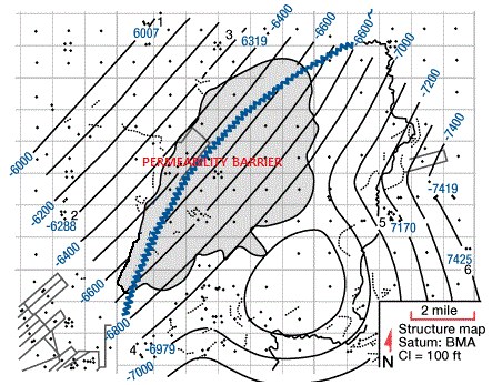
and the three updip holes had tight Sligo Limestone.

structural closure post Sligo BMA level , Geological prospecting, Petroleum exploration, Reservoir modeling, Seismic interpretation, Well log analysis, Stratigraphy, Structural geology, Petroleum systems, Source rock analysis, Hydrocarbon potential, Reservoir characterization, Prospect evaluation, Trap types, Migration pathways, Seismic surveys, Petroleum geophysics, Play fairway analysis, Basin analysis, Rock properties, Porosity and permeability, Reservoir engineering, Well testing, Production forecasting, Reserves estimation, Risk assessment, Prospect model
FIGURE 7

A structural closure at the post-Sligo “BMA” level was postulated (Figure 6) together with a permeability barrier (Figure 7).

A seismic survey disproved the structural turnover but indicated a structural nose which together with the permeability barrier, provided for a large stratigraphic trap. The Black Lake reef prospect contained 156 million barrels of in-place oil and condensate and nearly 8.9 1012 cu ft of gas-in-place.

Previous page 1 2 3 4 5 6 7 8 9 10Next page

Related Articles

Leave a Reply

Your email address will not be published. Required fields are marked *

ad
Back to top button