Related Articles


The Red Fork Channel Sandstone Model
Figure 1 is an isopach map for an interval between the basal Pennsylvanian (Upper Carboniferous) unconformity and an excellent regional marker (Pink lime) about 200 ft above.

The unconformity surface in north-central Oklahoma displays stream channels and intervening hills that developed on top of uplifted and eroded Mississippian (Lower Carboniferous) limestone.
Thick alluvial sands of Red Fork age (basal Pennsylvanian) were deposited in the stream channels (Figure 2). The channel-filling sands are often excellent stratigraphically trapped reservoirs, although in certain places they may be only one well location wide.
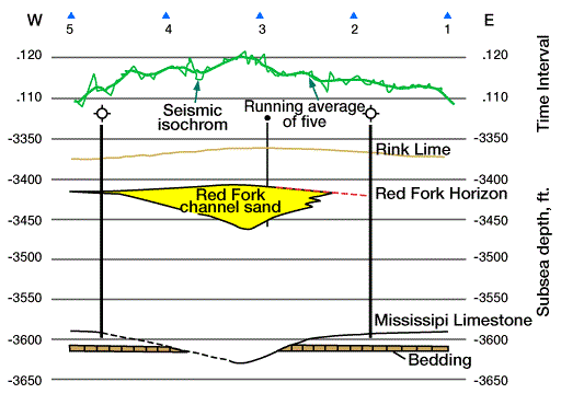
The seismograph is useful in predicting the courses of Red Fork channels because the Pink limestone and the top of Mississippian limestone are reliable picks on squiggle records (Figure 3).
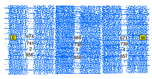
Figure 1 was made by combining log thicknesses from boreholes with seismic time intervals converted to feet. The prospects generated by this combination of geophysical and geological efforts might be either extensions of old channel sand reservoirs, interconnections between known reservoirs, or newly detected channelized meanders which loop updip.
With older seismic data, as in Figure 3, following a Red Fork sand is an indirect exercise because the isopach map directly depicts the channel configuration and only loosely indicates the occurrence of a sand body (newer seismic surveys can be tailored to detect the channel sand itself). For an elementary discussion of how seismics can be used to delineate lithologic bodies the reader may consult Anstey (1982), or refer to the section titled “Basic Interpretation” that is found in the IPIMS Geophysics discipline under the subject of Seismic Interpretation. Usually it is the geologist who points out to the seismologist what new plays may be feasible in a given region. Then the seismologist looks at the records to see whether the concrete data needed to start such a new play can be found.