Related Articles


Diagnostic Evidence Eolian Environments
Seismic eolian environments
In general, subsurface dune deposits are not detectable as such by existing seismic methods. Sheet-like geometry, association with unconformities, and absence of good internal reflectors are, as mentioned, also typical of the overall response generated by braided stream sediments (see previous discussion), which may over or underlie eolianites and thus further “mask” them. Seismic data, therefore, are perhaps most useful in delineating the depositional limits, rather than the actual lithology, of a potential dune reservoir.
Wireline Logs eolian environments
Figure 1 (Log motifs for eolian sands.
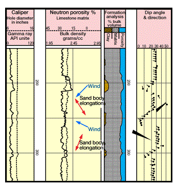
Note the well-developed blue pattern of upward-increasing dips along the toeset-foreset transition in individual dune units.) shows a suite of logs typical of the eolian Rotliegendes (Permian) group, a productive reservoir in the North Sea. Despite an overall blocky appearance, the gamma-ray curve can be divided into approximately 50-foot increments, all bordered by narrow spikes of higher radioactivity. Thus, the general profile can be more accurately described as “saw-toothed.” Each of the small kicks (which are more obvious on the density log curve) is asymmetric, with a sharp base and a gentle upward decrease in API units. They are caused by the finer-grained, mica-containing toeset layers of each new dune that abruptly truncate the underlying foresets of the underlying dune unit. The wind blows this finergrained sediment farther out from the dune crest. It thus settles at the base of the dune, while the coarser quartz grains remain along the slip face. It is this particle size differentiation that gives the strong concave-upward curve to eolian crossbeds. Note how the kicks on the gamma ray curve correspond with both the neutron-density and dipmeter logs.
The 50-foot interval is also strongly evident on the latter. Each increment begins at the base with low angle dips (toeset beds), which then increase in amount upwards until reaching a maximum of about 25° to 35° (foreset beds). This maximum is the most conspicuous part of the dipmeter log and indicates both the large size and consistent orientation of the cross-bedding. Dip azimuths are very constant, directly indicating the downwind direction. This, in turn, reveals the local elongation of the sand body. As Figure 2 (Relationships between dune morphology and the orientation of cross-bedding.
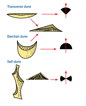
Far right diagrams show azimuth frequency.) shows, this elongation will be perpendicular to the downwind direction. Between the stacked dune units, as shown in Figure 1, this direction will vary considerably; thus accurate determinations of the principle paleocurrents can only be made from a relatively large number of readings. Modern day sand ‘seas” are often characterized by two or more major wind directions (Ahlbrandt and Fryberger 1982). There are only a few, isolated parts of the log that appear to show the low angle green, or structural, dip motif. Again, the most salient feature of dipmeter logs in this facies is the pronounced domination by foreset bedding, with its often-steep and highly consistent readings.
Cores
Samples of eolianite sections are commonly comprised almost entirely of clean, well-sorted quartz sandstone (often called orthoquartzite). Detailed sedimentological analysis — which examines such aspects as grain mineralogy, size, sorting, rounding, as well as surface characteristics through both microscopic and mathematical techniques — has not proven its unqualified worth in strictly distinguishing dunes from some transitional marine facies. Eolian sand is often reworked from older deposits, and thus such study may reveal mostly “inherited” features. This, however, is only a cautionary note; such analysis is absolutely necessary to almost all facies identification — for the geologist, nothing can replace or supersede first-hand examination of the rocks themselves.
As indicated by the dip log, steep and, at times, monotonously consistent cross-bedding is the prominent sedimentary structure found in most cores. In addition, smaller-scale ripples, graded beds, evenly laminated beds, and coarser pebble lag layers along surfaces that divide dune sets are sometimes seen. Traces of oxidized “impurities” between sand grains — whether ferric iron, spores, heavy minerals — can be significantly diagnostic. Certainly, as with alluvial fan and braided stream deposits, coloration can be used (with appropriate caution) as evidence.
The surface features which might be seen in cores, e.g., desiccation cracks, raindrop impressions, etc., also exist in the braided stream environment and cannot be considered diagnostic. Alone, core samples will rarely determine whether a deposit is eolian or not. More often, they must be used in conjunction with detailed log and stratigraphic information.