Related Articles


Mississippi Wilcox Model
Hazlit Creek field, Wilkinson County, Mississippi is an example of a logical process of prospect generation. It is an 800-acre, 5,000,000-barrel, multipay field producing from Eocene Wilcox sands. The field is not especially important in itself, but is included here for two reasons: first, it is typical of hundreds of small Wilcox fields already discovered in the trend, and undoubtedly of many more yet to be discovered; and second, it illustrates the use of a simple structural prospect model, and the following of logical prospecting procedures that can lead to a discovery.
The initial prospect is shown on Figure 1.

It is a structure map contoured on a prominent shale horizon. Central Oil Company No. 1 Bagg, a dry hole located in section 38, encountered oil shows in the Minter sand. In the subsequent northeast offset, the Minter was shaley but it still had traces of oil saturation. Then the Biglane dry hole in section 7, although without Minter oil shows, came in high to regional dip and allowed, by optimistic contouring, for an anticlinal closure to be mapped to the north. The shows and the structural high are typical of the model anomaly for this trend, and a prospect was generated on the proposed anticlinal crest (sections 37 and 41) (Figure 1).
Then Germany-Gulmon No. 37-1 was drilled at the proposed location shown in Figure 1. It had a good show in the Minter sand, but was too tight to produce (Figure 2).
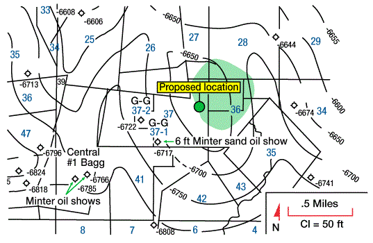
Next, the 37-2 well was low and had no shows, but it moved the prospect to the northeast and imparted a northerly strike to the feature. The discovery well was drilled at the proposed location shown in Figure 2 because it seemed to provide a good structurally high test for the overall Wilcox section. The discovery well had two pays, plus the Minter sand with noncommercial shows.
Such a sequence of events is rather typical of the prospect generating process in many geological trends. The subsurface geologist, of course, must keep up with the shifting structural contours at several levels as new well control becomes available in an active play. As logs are made public, it is equally important that he quickly detect significant changes in sand edges, in porosity limits, in carbonates, in hydrocarbon shows from the grass roofs to total depth, in indications of fracturing from sonic and density logs, and in all other anomalous properties.