Related Articles


Stratigraphic Models
Most stratigraphic models simulate the time-varying response to basin-scale controls of climate, eustasy, tectonics, sediment supply or production, and lithospheric compensation. Accommodation space for sediment is created through the interactions of tectonic subsidence, eustasy, lithospheric compensation, and compaction of previously deposited sediments Figure 1, Accommodation potential is the space available for sediment fill within a depositional basin.
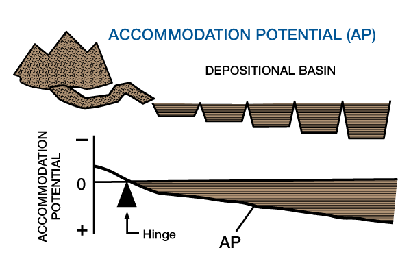
Stratigraphic models create accommodation potential for sediment fill by interactions of tectonic subsidence, eutasy, lithospheric compensation, and compaction.). A specified volume of sediment is distributed within the accommodation space using algorithms for sediment transport and deposition Figure 2, Realized accommodation potential is that portion of potential accommodation space that is filled with sediment.
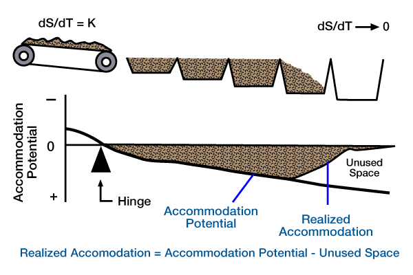
Sediment is delivered to a basin by a hopper car at a steady rate. All of the available space is not used.). Model outputs commonly consist of stratigraphic cross sections that show the distribution and volumes of lithologies, and variations in water depth (Figure 3).

Stratigraphic models contain many of the assumptions, limitations, and potential inaccuracies of the other models. For example, most stratigraphic models assume that sedimentation and geodynamic equilibrium conditions are reached between the time intervals of the model. The assumption that equilibrium conditions of different real-world attributes approximate a dynamic system may not be correct. Consequently, we must continually analyze the accuracy and precision of the information and approximations taken from sedimentation and geodynamic models and used in stratigraphic models.
Usually, sediment transport and deposition are not simulated dynamically, as in sedimentation models. Instead, we use empirical generalizations, geometric constraints, or inferences from sedimentation models — or a combination of these approaches to constrain the position, geometry and lithology of sediment eroded, transported and deposited during each time interval of the model. Stratigraphic models rely heavily on empirical generalizations for developing algorithms designed to simulate the real world. Examples include carbonate productivity as a function of one or more variables (e.g., water depth, turbidity, nutrient level), and the response of river morphologies and grade to changes in base-level. Lithology estimates are normally determined by some type of empirical calibration (e.g., water depths < 30 m indicate sands and water depths > 30 m indicate muds), or through combined diffusion equations that transport two or more synthetic grain-size populations at differing rates.
These inherent disadvantages, however, can also be advantages. Because stratigraphic models are partially based on empirical generalizations, they are likely to produce reasonable approximations of the real world, even if they do not simulate all the processes and responses at work in the formation and evolution of sedimentary basins. Because stratigraphic models are intermediate in scale to geodynamic and sedimentation models, they are gradually incorporating more of the dynamic elements of the other two. This means that an increasing number of process/response variables will be incorporated into stratigraphic models, and that they will combine some of the best attributes of the other model types. Another advantage of stratigraphic models is that we can use them to make specific predictions which we can evaluate at a higher resolution and with a greater volume of information. For example, geodynamic models make predictions only about stratal thicknesses and not about lithologies or stratigraphic architecture. As more aspects of geodynamic and sedimentation models are incorporated into stratigraphic models, we will be able to use stratigraphic models to make predictions about lithologies, facies volumes and connectedness, and stratigraphic architecture, as well as stratal thicknesses.